Q-system Rock Mass Classification Calculator
A free, simple Q-system rock mass classification calculator for evaluating underground excavation stability in jointed rock masses.
Calculator
Q-system Formula
The Q-value is calculated using the following equation:
Q = (RQD/Jn) × (Jr/Ja) × (Jw/SRF)
RQD = Rock Quality Designation
Jn = Joint Set Number
Jr = Joint Roughness Number
Ja = Joint Alteration Number
Jw = Joint Water Reduction Factor
SRF = Stress Reduction Factor
Block Size (RQD/Jn)
Represents the block size and degree of jointing
Shear Strength (Jr/Ja)
Represents the shear strength of joints
Active Stress (Jw/SRF)
Represents the active stress environment
Q-System Rock Mass Classification Guide
Rock Support Chart
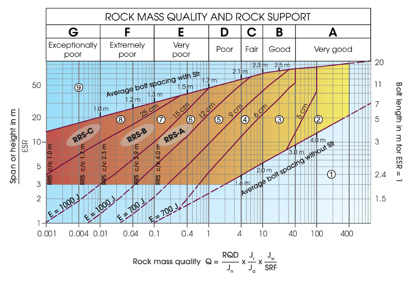
Q-system Rock Support Chart showing the relationship between Q-value and recommended support measures
Source: NGI (2025). Using the Q-system—Rock Mass Classification and Support Design. Norwegian Geotechnical Institute.
What is the Q-system?
The Q-system is a widely recognised method for classifying the stability of underground excavations in jointed rock masses. It distils a handful of geotechnical parameters—such as joint set count, roughness, and water inflow—into a single Q-value that captures the overall quality of the rock mass. A higher Q-value points to more stable rock conditions, while a lower Q-value flags areas that might need extra support or design adjustments.
Why & When to Use the Q-system
The Q-system suits everything from tunnelling to building caverns, helping you quickly get a grip on rock quality and make decisions on support. Whether you're designing a new excavation or keeping tabs on changing ground conditions in an active project, the Q-system streamlines a lot of technical data into one straightforward metric. This lets engineers, geologists, and planners compare sites, monitor developments over time, and stay one step ahead of any stability issues.
Our free Q-system calculator brings all this to your screen with just a few clicks. Input some basic rock mass details—like joint spacing and groundwater conditions—and the tool does the maths. You'll get a clear Q-value that reflects how strong or weak the rock mass might be, along with insights on what that means for reinforcement or excavation design. It's an ideal tool if you want practical, no-fuss evaluations without burying yourself in complex software or manual calculations.
Key Resources
- Barton, N, Lien, R & Lunde, J (1974). Engineering Classification of Rock Masses for the Design of Tunnel Support. Rock Mechanics and Rock Engineering, 6(4), 189-236.
- Grimstad, E & Barton, N (1993). Updating of the Q-system for NMT. In: Proceedings of the International Symposium on Sprayed Concrete. Fagernes, 46-66.
- Barton, N & Grimstad, E (2014). An Illustrated Guide to the Q-system Following 40 Years Use in Tunnelling. Available from www.nickbarton.com.
- NGI (2025). Using the Q-system—Rock Mass Classification and Support Design. Norwegian Geotechnical Institute.
More Free Tools
Mine Slope Geometry Calculator
Visualise and design stable mine slopes with interactive geometry tools. Optimise bench height, batter angles, and overall slope configurations for open pit mining operations.
Mine Safety Bund Calculator
Quickly and easily calculate the geometry for a mining-compliant safety bund.
Coal Mine Roof Rating (CMRR)
The CMRR calculator aids in the evaluation of underground coal mine roof stability by providing a rating that combines rock core logging with visual assessment.
LAS Geophysics Visualisation & Analysis
Visualise and analyse borehole wireline geophysical log data from LAS files with this interactive tool.
Packer Test Stage Gauge Pressure Calculator
Calculate the gauge pressure for each stage of a water pressure (packer) test, helping engineers determine the appropriate pressure for each stage.
Geotechnical Dictionary
A dictionary of geotechnical terms and their definitions, helping engineers understand and interpret geotechnical logging data.
Geotechnical Engineering Standards & Guidelines
Comprehensive searchable database of engineering standards including Australian Standards (AS), ISO, and ASTM for geotechnical engineering, soil testing, rock mechanics, and foundation design.
Sonic Uniaxial Compressive Strength (UCS)
Estimate the uniaxial compressive strength (UCS) of rock materials through non-destructive sonic testing, providing crucial data for geotechnical engineering.
Point Load Strength to Uniaxial Compressive Strength (UCS)
Convert point load strength index values to UCS for rocks using empirical correlations, facilitating quicker field assessments without extensive laboratory testing.
The Global Interactive Mining Project Database
Explore thousands of global mining projects with an interactive map. Discover mines, tunnels, and dams worldwide. Filter by status, country, owner, and commodity to find projects that matter to you.